I have been away for the last 10 days to
participate in the AG211 marine geology cruise to the northeastern part of the
Svalbard archipelago. The aim of the cruise was to learn more about marine
sediment cores, foraminifera and marine floor landforms and how these can be
used as tools for paleoclimatic studies.
One of the tools we used was a Multifrequency chirp (http://en.wikipedia.org/wiki/Chirp).
It sends a coneshaped acoustic ping down to the bottom floors using several
frequencies (hence multi) and gives us a 3-dimensional picture of the seafloor.
It also penetrates sediments which gives a profile of the sediments covering
the bedfloor. Using this, we can identify different landforms like moraines,
flutes, hill-hole pairs and iceberg scours.
In total we took up 7(?) gravity cores north and east of Nordaustlandet.
 |
| Travel route. (Map from www.sailwx.ino) |
Day 1 Monday 05.sept 2011:
Departure day
We left the harbor in Longyearbyen with the research vessel F/F Helmar Hansen (Earlier F/F Jan Mayem) around 11.00am.
We carried our luggage down to our room which I shared with Jochem and Francesca. I had the bottom bed, with Francesca above. This would normally involve Fran stepping on me when she climbed in and out of bed. Then again. I sleep in the most awkward positions with hands and arms sticking out everywhere, so I take some blame for that. Later we had a small lecture in the ships audiotorium.
 |
| Research vessel F/F Helmar Hansen (Photo: Alexander Hovland) |
We carried our luggage down to our room which I shared with Jochem and Francesca. I had the bottom bed, with Francesca above. This would normally involve Fran stepping on me when she climbed in and out of bed. Then again. I sleep in the most awkward positions with hands and arms sticking out everywhere, so I take some blame for that. Later we had a small lecture in the ships audiotorium.
 |
| Lougar (Foto: Alexander Hovland) |
Weather was okey with a little bit of clouds and wind from the south. This made the ship roll a little bit as we went west out of Isfjorden. This got better when we started going north along the westcoast of Prins Karls Forland.
 |
| People hanging in the mess hall (Photo Kristian Gram Sloth) |
The rest of the day we didn't really do anything interesting. Outside it got really foggy and the visibility was poor. Time therefore passed by watching movies, reading or sleeping between the meals. These were served three times a day 07-08-30, 13.30-14.30 and 19.30-20.30 and consisted of different types of hot meals and cake at around 11.00 and 17.00.
Noon position: Not recorded
Day 2 Tuesday 06.sept 2011:
Moffen, Nordaustlandet and coring
This morning we had anchored up outside Moffen which is north of Gråhuken on Spitsbergen. Moffen is a small island built up by a series of beaches on a shallow bank with a drop-shaped lagoon of brackish waterin the center. Because the topography of the island is almost completly flat it is ideal for walruses and according to the norwegian polar institute it is the most important resting area for walrus (Odobenus rosmarus). Normally there should be around 300 walruses in the area, but there were only 2 or 3 on the beach today.
 |
| Moffen can barely be seen in the horizon (Photo: Alexander Hovland) |
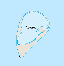 |
| Map of Moffen (Source: Svalbardkartet) |
We had a small lecture in the middle of the day about the general history of glaciations as well as an introduction to the various geophysical methods we were going to use. Meanwhile the boat headed for Nordaustlandet.
In the afternoon we arrived at Rijpfjorden which cuts inn between Vestfonna and Austfonna (tr. "Western glacier" and "Eastern glacier"). As we started going into the fjord we started chirping which would involve going back and forth parallel to the fjord for the next two days in order to cover the whole through which runs out to the continental slope.
One of the characteristics with the chirp is the ticking noise it makes when the accoustic signal hits the hull of the ship. The first two nights I lay awake for quite a while listening to it before I feel to sleep. After that its more comfortable as it it shows everything is working.
The weather was somewhat okey. Waves had increased a little bit, but the fog cleared a little so we could see the coast which for most part appeared quite barren.
 |
| Rijpfjorden with Vestfonna barely visible over the hill (Photo: Alexander Hovland) |
One of the characteristics with the chirp is the ticking noise it makes when the accoustic signal hits the hull of the ship. The first two nights I lay awake for quite a while listening to it before I feel to sleep. After that its more comfortable as it it shows everything is working.
 |
| Nichlas on chirpwatch. And yes. We used all the screens. (Photo: Alexander Hovland) |
During the evening team 1-3 who was working in the inner parts of the Rijpfjorden, retrieved their gravity- and box cores from the ocean floor.
Noon position: 80O22'0" N
017O22'620"E
Wind 4,68m/s 292o 3,2oC 1005hPA Cloudy
Wind 4,68m/s 292o 3,2oC 1005hPA Cloudy
Day 3 Wednesday 07.sept 2011:
Moffen, Nordaustlandet and coring
Around 03.00am I had to wake up for my first chirping watch. The watch involved making sure the instruments were running and change printerintervalls as the depth changed. Later however, the chirping-watch would also include stopping and starting the different instruments as the boat stopped for coring or during turning. The watch lasted for one hour. However, after my watch, I went to read a little bit. At 04:56 I have recorded "First snowfall!". During the rest of the cruise I had chirpwatches changing between 09.00-10.00, 15.00-16.00 and 03.00-04.00
During the morning both wind and waves increased. We were supposed to start coring, first in the morning, then around noon but did not start until the late evening due to the weather. This time we were taking up a gravity core which is basicly a heavy 2 ton steel tube that penetrates the sediments on the seafloor using it own weight. On the open end, there is a cone shaped core catcher made out of an alloy of magnesium and bronze which traps the sedimentcore from going out by the use of a peel closing system.
When the core is up on deck there are several things that has to be done:
 |
| First morning with snow (Photo: Alexander Hovland) |
 |
| People eating (Photo: Alexander Hovland) |
 |
| Gravity core coming up (Photo: Alexander Hovland) |
 |
| Gravity core coming up (Photo: Alexander Hovland) |
 |
| Cleaning the liner (Photo: Alexander Hovland) |
 |
| Cutting and marking the sections (Photo: Alexander Hovland) |
 |
| Francesca being excited :O (Photo: Alexander Hovland) |
 |
| Instructions and label for our core (Photo: Alexander Hovland) |
 |
| The core catcher (Photo: Alexander Hovland) |
 |
| Taking our first look on the cores before freezing them (Photo: Alexander Hovland) |
1. Bag core catcher/cutter samples if any
2. Retrieve PVC linear from the barrel
3. Cap the bottom end of the liner
4. Measure and cut the liner according to the length of the sediments in it
5. Cap and tape the top end of the liner
6. Clean and dry the liner
7. Measure and mark the liner the 1m long sections starting from the top of the core
8. Mark the top of each section with an arrow
9. Cut the core sections; cap and tape liner ends
10. Bring the core inside; clean the liner and repeat the indexing on the opposite side of the liner, and on end caps.
11. Fill in the station log sheet
12. Store the core in the cold room.
Meanwhile the weather got worse and people, including me, started to get seasick. By the evening most people had either threw up or were seasick.
Noon position 81o22'206"N
022O14'386"E
Wind 10.9m/s 79o -1,4oC
1007hPA Foggy
Day 4 Thursday 08.sept 2011
Being sea-sick in the arctic ocean
Sea was less calm this morning, however, very few people meet up for breakfast. After breakfast I went back to sleep. Later in the day we split our core in two halves and decided on a archive half and a working half (the most interesting of the two) that we would continue analyze later on the cruise. After that I went back to bed again.
Later we helped taking up a box core which for the most part involves cleaning the deck and the box corer. We also took a push core from the box core. This involves pushing a smaller tube into the sediments of the box core so it can be stored and later analyzed. When taking a gravity core the top layers are often ruined, so then the push core can be used to make a more complete stratigraphy from the conditions today and back.
 |
| Box corer breaking the surface (Photo: Alexander Hovland) |
 |
| Box corer (Photo: Alexander Hovland) |
 |
| Box corer on deck (Photo: Alexander Hovland) |
And yeah. Went back to bed again.
Noon position 81o02'626"N
025O43'750"E
Wind 6,71m/s 341o 0oC 999,2 hPA
Wind 6,71m/s 341o 0oC 999,2 hPA
Day 5: Friday 09.sept. 2011
Logging and foram work
The weather was better today, but still it is quite foggy. Sea-sickness is also for the most part over, althought people are still sleeping quite alot.
We started to log our core which involves describing changes in sediment size, type, structure, color etc. and making an overview of how our section looks like. The first two meeters of our core was basicly just glaciomarine mud with smaller organic particles. The last 50cm long section however showed a little bit more variation with changing conformal bands of siltyclay and more silty sand which we now belive might have been ice-rafted material (IRD) which later has been redeposited by turbidite flows. We also found 3 fine-gravel sized clasts, one being metamorphozed schizt and the two others were dolomites.
 |
| Working on the cores (Photo: Alexander Hovland) |
IRD clasts are interesting because the lithology might say something about their origin and water flow. For example. While metamorphozed scizt is found on the northern coast of Nordaustlandet, dolomite is not. The closest area is on the other side of Austfonna in Wahlenbergfjorden. This might indicate that the IRD is not from Rijpfjorden, but actually icebergs that has travelled through the Hinlopen strait and north towards the continental slope before melting.
 | ||
| Clasts (Photo: Alexander Hovland) |
 |
| Perfect example of IRD with 15cm+ clasts (Photo: Alexander Hovland) |
After finishing the prelimanry log of our sections we tried measuring magnetic suseptibility (MS). This is a hand held instrument (Bartington MSE2 high resolution magnetic susceptibility sensor) which measure the content of ferrimagnetic matter (magnetite, titanomagnetite or magheimte) which might help to identify changes in the genesis of the sediments. The measuring is done by placing a handheld scanner on the surface of the sediments at equal intervalls through the whole core. It then calculates MS values and corrects for non-linear changes in temperatur etc. which might effect the measuring.
However. It did not seem to work as we were getting negative values. We therefor decided that core might still be to cold and we left it to heat over the night. Meanwhile we started to work on foram-samples.
Foraminifera is tiny amoeboid protists which has a shell made out of calcium carbonate (CaCo3) or agglutinated particles. Our work was to pick them out of samples from different parts of the core and try to identify them with the help of Dr William E. N. Austin from the university of St. Andrews (http://www.st-andrews.ac.uk/gg/people/austin/). One thing is that I've never used a microscope before, another thing is that it is bloody hard to pick out these small buggers when you're on a ship in the middle of the arctic ocean.
In the evening the boat went eastward past Kvitøya and alongside the russian border toward the Barents sea loophole.
 |
| Looking for forams (Photo: Kristian Gram Sloth) |
Noon position: 80o59'472"N
025o57'577"E
Wind: 10m/s 49o -1,5oC 1008hPA
Wind: 10m/s 49o -1,5oC 1008hPA
Day 6 Saturday 10.sept. 2011
More corework
I tried to get out bed early today. However, as I sat my foot down on the floor the boat was rolling really heavily. Hid under the blanket for another hour until breakfast.
Did more work on our cores. Finishied the MS and a shear strength analysis. The shear strengt is often used as an indicator of ice-rafted debris (IRD) as these sediments often are more compacted then the surroundin sediments. To measure it, we use a little manual instrument which drops a cone shaped weight into the sediments. The depth is then measured and converted to shear strength.
We also continued the work with the forams having collecting 8 samples including one from the core catcher and the box core.
Still foggy outside.
Noon position: 80c32'205"N
32o37'548"E
Wind: 6.4m/s 144o 1.5oC 1009hPA
Wind: 6.4m/s 144o 1.5oC 1009hPA
Day 7 Sunday 11. sept. 2011
Finishing with forams
Finished with our forams today and the results are shown in the pies underneath.Changes in the composition of species normally reflecs as a change in the environment. An example is the benthic foram Cassidulina Teretis which only exist in the arctic ocean when warmer and more saline atlantic water is present. Therefor changes in the abundance of this specie can be interpretated as a change in the water circulation system.

Some cores were also taken up for later research projects.
Noon position: Somewhere east of Kvitøya
Wind: 2,6m/s n/ao 0,5oC 1009hPa (Rec: 21.00)
Day 8 Mondag 12.sept
Preparing presentations
Today started with team 1-3 presenting their results. Afterwards we spent the day preparing our presentation for the next day.
Today started with team 1-3 presenting their results. Afterwards we spent the day preparing our presentation for the next day.
Noon position 79o16'009"N
34o36'948"E
Wind: 6.5m/s 25o 2oC
1002hPA
Day 9 Tuesday 13. sept
Presentations and more bad weather
Presentations and more bad weather
Woke up today with the boat rolling heavily. Presentations were postponed twice due to big waves and a lot of people staying in their beds. First half of the day was spent watching movies and reading.
Around 15.00 we had our presentation which for the most part went okey, althought I screwed up a little bit by starting an old version of our powerpoint.
As I went to bed I immideatly noticed that the ticking of the chirp was gone. The chirp was turned off as we now had started to head home. On the way back to Longyearbyen we would go back north of Spitsbergen through the Hinlopen straight.
Weather outside is still foggy but forecast for tommorow is better.
Noon position: 79°12' N 032°06'E
Wind: 9.6m/s 50° -1.1°C 1007hPA
Around 15.00 we had our presentation which for the most part went okey, althought I screwed up a little bit by starting an old version of our powerpoint.
 |
| Francesca presenting our forams (Photo: Kristian Gram Sloth) |
As I went to bed I immideatly noticed that the ticking of the chirp was gone. The chirp was turned off as we now had started to head home. On the way back to Longyearbyen we would go back north of Spitsbergen through the Hinlopen straight.
Weather outside is still foggy but forecast for tommorow is better.
Noon position: 79°12' N 032°06'E
Wind: 9.6m/s 50° -1.1°C 1007hPA
Day 10 Wednesday 14.sept
Heading home
Heading home
Woke up this morning as we were entering through the Hinlopen straight. The fog was now clearing up and in the horizon we could now actually see land. Later in the day the weather turned out to be really nice and sunny althought there was quite a cold wind. However, for the first time in days, I actually spent quite a lot of time on deck.
We also passed a cople of boats, including the dutch sailship Barquentine ‘Antigua’ (http://www.classic-sailing.co.uk/vessels/antigua-tall-ship) a little east of Biscayarhuken.
On our way home we took a small detour into the calving Smeerenburgbreen at the end of Bjørnfjorden for some group-pictures. The landscape and the glaciers here was really beautifull and I spent most of the time taking pictures or just watching the landscape. Sadly we did not see any polar bears hanging around.
In the evening we started to clean up the labs and pack the cores for transport to UNIS where we will continue working on them.
Noon position: 79°54'748 N 12°04'020"E
Wind: 4.3m/s 92° 2.1°C 1000hPA
We also passed a cople of boats, including the dutch sailship Barquentine ‘Antigua’ (http://www.classic-sailing.co.uk/vessels/antigua-tall-ship) a little east of Biscayarhuken.
 |
| Barquentine ‘Antigua’ (Photo: Alexander Hovland) |
On our way home we took a small detour into the calving Smeerenburgbreen at the end of Bjørnfjorden for some group-pictures. The landscape and the glaciers here was really beautifull and I spent most of the time taking pictures or just watching the landscape. Sadly we did not see any polar bears hanging around.
 |
| Danskeneset (Photo: Alexander Hovland) |
 |
| Frambukta and Frambreen (Photo: Alexander Hovland) |
 |
| Smeerenburgbreen surrounding the nunatak Havhestfjellet (Mountain of the Northern Fulmar) (Photo: Alexander Hovland) |
 |
| Sellströmbreen (Photo: Alexander Hovland) |
 |
| Beerenburgbreen (Photo: Alexander Hovland) |
 |
| Magdalenabreen (Photo: Alexander Hovland) |
 |
| Little bit too late to get the calving (Photo: Alexander Hovland) |
 |
| Icebergs (Photo: Alexander Hovland) |
 |
| Me looking smart infront of Magdalenabreen (Photo: Kristian Gram Sloth) |
 |
| We got 14 people in there! (Photo: Kristian Gram Sloth) |
 |
| The northern fullmar looks really small in comparisment (Photo: Alexander Hovland) |
 |
| Northern fullmar (Photo: Alexander Hovland) |
 |
| Group-photo and no-one knows which camera to look into (Photo: Alexander Hovland) |
In the evening we started to clean up the labs and pack the cores for transport to UNIS where we will continue working on them.
Noon position: 79°54'748 N 12°04'020"E
Wind: 4.3m/s 92° 2.1°C 1000hPA
Day 11. Thursday 15. sept
Arriving at Longyearbyen
It was a foggy morning, but as I looked out I could see Bjørndalen which is right west of Longyearbyen. After breakfast we arrived at the harbour and the cruise was over. Feeling solid ground underneath my feet was amazing. I'm obviously not a boat person...
Arriving at Longyearbyen
It was a foggy morning, but as I looked out I could see Bjørndalen which is right west of Longyearbyen. After breakfast we arrived at the harbour and the cruise was over. Feeling solid ground underneath my feet was amazing. I'm obviously not a boat person...